

Field Guides
Crosbyton, Texas
(Crosby COUNTY)
Cotton fields, ranch life, and sunsets that stretch forever.
Highlights
Driving around Crosby County will teach you much about Texas geography. Two terms you will hear bandied about frequently by people who seem to know what they are talking about are the “Llano Estacado” and the “Caprock Escarpment.” They meet in Crosby County and produce some unusual and beautiful geology.
For a deep dive into the Llano Estacado, check out the History section, but the short story is that the name refers to one of the largest areas of “plains,” meaning tablelands and mesas, in North America. The area straddles the western side of the Panhandle and eastern New Mexico, including Amarillo, Lubbock, Odessa, and Midland. Crosby County is on the eastern edge of the Llano Estacado. The Llano Escatado is elevated, gently rising from about 3,000 feet above sea level to the southeast to almost 5,000 feet in the northwest (in New Mexico).
The Caprock Escarpment is the border of the Llano Estacado. An escarpment is a geological term referring to an area of sudden elevation change, typically characterized by a cliff or steep slope, and often marking the separation point between two distinct areas of elevation. “Caprock” refers to the layer of red rock underlying the Llano Estacado. Over millennia, rivers have carved away this layer of caprock, creating an escarpment that is particularly striking due to its deep red hue. Thus, driving on the east-to-west roads, you can see unexpected and often beautiful scenery.
This last part will sound strange, but if you travel Texas highways, you will understand. Crosbyton, Texas, boasts the best rest stop in the State. So, while it is likely that you will only be passing through Crosby County and Crosbyton, if you want to enjoy a picnic lunch on the roadside, this is the perfect spot to do it. Otherwise, Crosby County is beef and oil country, with much of the land devoted to pursuing and protecting these resources.
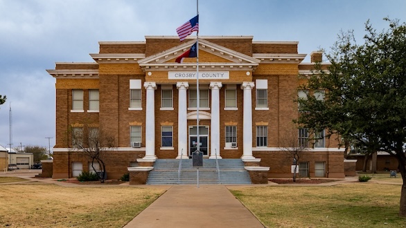
The County Courthouse
Crosby County’s seat of administration and justice looks like a plains courthouse should look. This structure rose in 1914, four years after Crosbyton became the county seat. Before that, there was a “traveling” courthouse. When the state organized the county in 1886, the county seat was at Estacado. After operating out of dugouts and wagons for two years, the county built a simple structure for its offices in 1888. Two years later, the county seat moved to Emma, and the courthouse followed suit.
Emma failed to attract the attention of the railways and suffered as a result. In 1910, Crosbyton became the third county seat, although it did not exist until its location near the railway made it the right real estate for the job. For the first four years in Crosbtyton, court and county offices shared room in a schoolhouse.
The county selected Fort Worth architect Marion Weller to design the building. The building is in the Neoclassical style, which draws inspiration from Greek and Roman architecture. In Crosbyton, the symmetry of the building, with its imposing columns, flat roof, and simple cornices, combines to communicate stability and order. We also appreciate the well-groomed but open courtyard, which is consistent with the overall landscape.
Things To See And Do
The primary feature of the Caprock Escarpment in Crosby County is Blanco Canyon, formed by the flow of the White River. U.S. Hwy 82 crosses Blanco Canyon in Crosbyton at the mouth of the canyon, where the canyon walls range from 300 feet to 500 feet high.
The water from the White River created Silver Falls, which is an actual waterfall, unexpected in West Texas but accessible from Highway 82 near the canyon. The roadside park built around the falls is the largest in Texas by area. The facilities are historic, constructed by the National Youth Association as part of the New Deal’s Works Progress Administration’s efforts. There is plenty of room to stretch your legs and explore, including a pleasant short hike.
Silver Falls is not Niagara Falls. Irrigation for both agriculture and oil wells reduced the groundwater that feeds the falls, as did the construction of the highway next to the park. That means you will see “a real waterfall” only after heavier rains, most often in the spring and fall. Even in drier weather, however, the stop is beautiful and historic.
For outdoor activities beyond a rugged hike along the river into Blanco Canyon, the White River Reservoir is a small lake in the southwest corner of the county that offers good bass fishing opportunities. Hunting for whitetail deer, mule deer, feral hogs, turkey, quail, and dove. If you are interested, we suggest Free Range Outdoors as the lords of the local information.
As detailed in the history segment, the area was a flashpoint for the meeting of Anglo and Native American cultures. The Crosbyton Pioneer Memorial Museum does a great job of telling that story, but it is currently closed for extensive remodeling. We look forward to the grand reopening.
Food, Drinks, And Music (Eat Local!)
Chieftain Grill is your non-chain store option in Crosbyton, but it is a good one, with overwhelmingly positive reviews for its home cooking. Taqueria Don Chuy also has a sterling reputation, but it is currently closed. In Ralls (‘the next town over”), the Jackrabbit Grill (home cooking) and Sarah’s (burgers) are your home cooking spots, while Estela’s covers Tex-Mex. In Lorenzo, the Little Ranch Cafe serves burgers and Tex-Mex in a quaint setting.
Where To Drop A Dime (Shop Local!)
In Crosbyton, Clear Creek Posse is an engaging thrift and consignment store.
The Name Dropper in Ralls is primarily a monogrammer, but also has gifts, including Mudpie dishes, which are Texas Ten favorite. Tumbleweed Market, also located in Ralls, is a worthwhile vintage, collectables, and who-knows-what-you-will-find store. We will miss Stuffology, a surprisingly great vintage boutique that just closed.
Special Places To Lay Your Head (Stay Local!)
The Smith House Inn is your best bet for an above-average lodging experience. If you have a large group, there is a six-bedroom short-term rental in Lorenzo. We have no idea what the inside looks like, but we loved the exterior of the Silver Falls Motel (no social media) as a classic motor court. Youth groups should check out Camp Rio Blanco, a Girl Scout Camp that is available for rental.
For The Professional Traveller (Campgrounds and RV Parks)
Special Events
The museum’s fundraiser is all about pork–the annual Pig Out each April. The Stock Show typically takes place in mid-January.
Fore! (Golf Courses)
Nothing in the county, but there are plenty of courses next door in Lubbock County.
Getting to Crosby County
Think just south of the center of the Panhandle. Crosby County borders Lubbock County to the east. U.S. Hwy 82 is a straight line between Lubbock and Crosbyton (the county seat) and Ralls (the other town). U.S. 62/TX FM 207 bisects Ralls going north and south. The closest interstate is I-27, which runs parallel to U.S. Hwy 62. The east-west Interstates (I-20 ot the south and I-40 to the north) are both more than 100 miles away. Big picture, Crosbyton is three hours and 50 minutes driving time north/northwest of the state’s geographic center in Bray, Texas.
Big planes will be arriving at Lubbock Preston Smith International Airport, which offers service via Southwest, American, and United. Smaller craft are welcome at Crosbyton Municipal Airport. For planes too big for the municipal airport, but wanting to avoid the hassles of large planes, ClearTech Aviation at Lubbock Executive Airpark should work.
History
Crosby County’s story starts 65 million years ago, when the Rocky Mountains erupted out of the earth’s surface in response to gigantic tectonic shifts as far away as what is now California. The after effects from the process that built the Rockies included lifting the earth’s surface to the West, including New Mexico and the western edge of the Panhandle. Rivers eroded the eastern edge of the area, creating jagged slopes and valleys with exposed red rock. The area of raised plains is the Llano Estacado, and the jagged boundary is the Caprock Escarpment.
Jumping ahead a bit in the story is necessary to discuss the name. In the 1540s, Spanish explorer Francisco Coronado led an expedition through the area in search of the fabled “Seven Cities of Gold.” (Spoiler alert-he did not find them.). He likely made a prolonged camp at Blanco Canyon. Although the archaeology places the camp closer to Floydada than Crosbyton, Coronado and his entourage almost certainly traversed Crosby County.
Coronado or someone in his group gave us the name. The first theory depends on a Spanish verb conjugation, using Estacado as a past participle to be the Spanish translation of the word “staked.” In this telling, Coronado’s Indian scouts knew that the plains looked the same everywhere, with no markers to measure progress. So they would launch their arrows straight ahead and move towards them. When they reached the implanted arrow, they would remove the “stake” and repeat the process. In that way, they avoided walking in circles by following a staked path.
The alternative version depends on the view of the Caprock Escarpment. The Spanish root for Estacado means “palisaded” or “fortressed.” The view westward from the plains into the escarpment does resemble a fortress protecting the plains from intruders on the eastern edge, so a “fortressed plain” would be a logical result. Both theories are romantic and worthy of the majestic land, so we are agnostic as to the correct version.
We do know that when Coronado crossed the plains, there was abundant tall grass, markedly different from what we see today. These tall grasses feed huge creatures throughout time, most recently the herds of buffalo. In turn, approximately 12,000-15,000 years ago, Native Americans began to call the Llano Estacado home, building their lives around the millions of buffalo that inhabited the region. The seismic shift that informs most of the known human history of the area began around 1700 A.D. It was then that one of the Native American bands, the Comanche, began to acquire horses and learned to conduct warfare while mounted.
The Comanche’s unparalleled horsemanship and fierceness led to domination of the plains for approximately a century and a half. The next sea change happened in 1845 when Texas joined the United States. Until then, whatever settlers had made their way to the plains were at a decided disadvantage against the Comanche. Now, a nation of “Manifest Destiny” that added huge chunks of the West through the Mexican-American War in 1848-1849 saw no reason that its control of all the land should be in doubt. Thus, in the late 1840s and early 1850s, U.S. Army Forts began to appear to the west and south of “civilized” Texas.
For a variety of reasons, the primary one being the vast expanse of land that the forts were meant to protect, the new installations were at best marginally effective. When Texas seceded, most of the forts were left vacant. The initial return of the Army after the Civil War focused on restoring Union control over the citizenry, as opposed to the Native Americans. By the late 1860s, however, the Army began a more concerted effort to remove Native Americans generally, and the Comanche in particular, from the plains.
The modern history of Crosby County began in 1871 as part of that effort. By that point, the Comanche were among the last holdouts unwilling to accept removal to “Indian land” in Oklahoma. Colonel Ranald Mackenzie received permission from the area’s commanding general, William Sherman (yes, the Sherman who destroyed much of the South during the last two years of the Civil War), to campaign against the Kotsoteka and Quahada bands of the Comanche. The famed Quanah Parker headed the Quahada.
Mackenzie and Parker sparred in an inconclusive battle that began and ended at Blanco Canyon, but also included a long foray onto the plains. Neither side gained a decisive advantage, although Parker did make off with about 60 of Mackenzie’s horses. The war raged throughout the Panhandle for four years, until Mackenzie’s victory at Palo Duro caused the removal of almost all the native American combatants and their horses, opening the Panhandle to settlement.
The first influx of Anglos in the area was temporary. The Buffalo Hunters spent the time between 1874 and 1877 plundering the herd into near extinction. The first permanent settlers were a cattle rancher and a Quaker colony. In 1876, the legislature formed the county, and by 1880, it had 82 residents.
Crosby County was formally organized in 1886. The county seat was first at “Estacado” and then at Emma, but both were short-lived, likely because they were not well-positioned when the railroads came to town. In 1910, Crosbyton became the permanent county seat. Moving the seat of government around was not a big deal because, in the early days, cattle far exceeded cattle. The land was largely part of large cattle operations, so that by 1900 the county had 30,000 head of cattle and 788 head of humans.
From 1900 to 1920, the economy changed, and the population grew. The introduction of barbed wire, the breakup of large ranches, the construction of cotton gins, and the availability of railroads to move goods to market all contributed to more people farming smaller acreages, with an emphasis on cotton cultivation. The 1920 census reported over 6,000 county residents, an almost 10-fold increase over two decades. The trend continued through the 1920s. Farmers added wheat and sorghum to the crop mix and included pork production in the livestock mix. The population almost doubled again, and humans (11,000) almost caught up to cattle (15,000).
The Great Depression and the Dust Bowl reversed these trends. After the economic devastation caused by these dual crises, the cost of effectively managing a farm made it difficult for smaller, family-owned farms. Thus, there has been consolidation, accompanied by a slow and steady decline in the population. Some relief came in the way of oil, first discovered in the county in 1955. While significant, fossil fuels were never the boom in Crosby County as they were elsewhere in the Panhandle. Today, energy production continues, but it is not a significant economic factor.
Instead, Crosby County is a modern ranching and farming community, with a small percentage of citizens commuting to the Lubbock area for work. The population is 56% Hispanic individuals, 39% Caucasian non-Hispanics, 2% African Americans, 2% individuals of mixed race, and 1% Asians. The median family income significantly lags behind state and national averages. The poverty rate is 50% above the average for the state. The high school graduation rate is 10% below the state and national norms, while post-secondary degrees are well behind, at 40% of the achievement rate elsewhere. The lower cost of housing, however, offsets some of the lower earnings.
Crosby County’s political history is relatively short compared to many Texas counties, as the county lacked a significant population until the early twentieth century. Like most of Texas, Crosby County voted for conservative Democrats through the early 1950s. The Eisenhower-Stevenson races in 1952 and 1956 saw a dip in support for Democrats throughout most of the state, but not in Crosby County, which strongly backed the Illinois senator. From that point forward, it is accurate to say that Crosby County followed the trend towards the GOP in Texas rural counties; however, its conversion is not as complete as it is in many counties with similar economies. For instance, the county opted for Bill Clinton over Bob Dole in the 1996 election. In 2024, the county’s votes went to President Trump, but he 63% majority he earned there is smaller than in most similar Texas counties.
The great Don Maynard was born in Crosbyton, although he played his high-school football for Colorado City. Maynard is a no-doubt Hall of Famer, as when he retired, he was pro football’s all-time leader in pass receptions and yardage. Early 1960s country star Billy Walker was from Ralls. Walker had several chart toppers, but may be best known for being the first to record Willie Nelson’s “It’s Funny How Time Slips Away” and for passing Willie’s gigantic hit “Crazy” on to Patsy Cline.